General Areas Inhabited by Gray Wolves in Colorado & CPW launches depredation report webpage
By Dave Shaffer

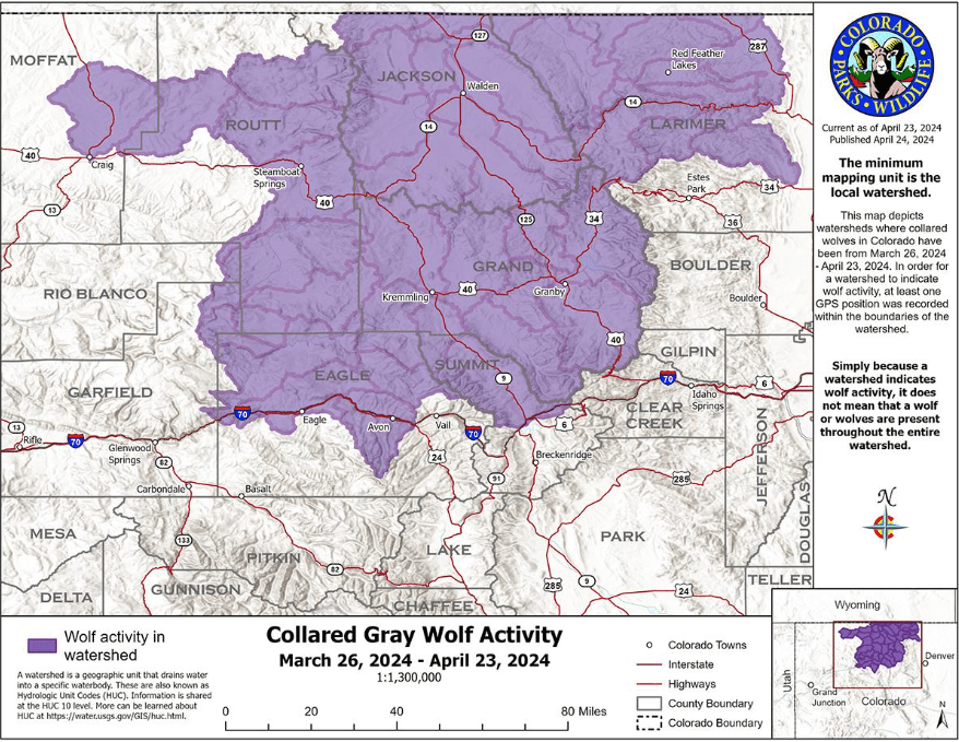
Collared gray wolf activity recorded by CPW from Mar. 26 to Apr. 23, 2024
Above is an updated map just published by Colorado Parks and Wildlife’s showing where collared wolves have been in the past month.
CPW also launched a new Gray Wolf Depredation Report webpage to inform the public about confirmed livestock depredations by wolves in Colorado. This page will be updated each time CPW staff investigates and confirms a new depredation event.
Notable Updates
- This map was created using GPS data from all functioning collars in Colorado.
- Two of the ten collars placed on wolves translocated in December are no longer providing signals to CPW biologists. This includes the collar that failed in March and an additional collar that was partially functional in March but has since failed. The animals with the failed collars are traveling with other animals with functional collars, which currently allows CPW to monitor those animals. CPW has confirmed that the animals with the malfunctioning collars are still alive based on visual confirmation from an airplane.
- Movements of reintroduced wolves have been confirmed in watersheds east of the Continental Divide and onto the Front Range.
- This will be the last press release announcing Collared Gray Wolf Activity Map updates. The website will continue to be updated with recent activity on the fourth Wednesday of every month. Sign up for CPW’s Gray Wolf Reintroduction Enews to stay informed.
- Statement from the U.S. Fish and Wildlife Service: On April 18, 2024, the U.S. Fish and Wildlife Service became aware of a deceased gray wolf in Larimer County, CO. As a federally listed species under the Endangered Species Act, the Service is investigating and has sent the carcass for a necropsy to determine the cause of death. Initial evidence suggests that this wolf likely died of natural causes, but a final determination will not be made until the necropsy is completed. This wolf was one of the ten recently released by Colorado Parks and Wildlife in December 2023, and the Service is working cooperatively with CPW in our investigation. No additional details are available at this time.
For comparison, below is the map for the previous month.

Collared gray wolf activity recorded by CPW from Feb. 28 to Mar. 25, 2024
Above is an updated map published today by Colorado Parks and Wildlife’s showing where collared wolves have been in the previous month.
Notable Updates
- This map was created using GPS data from all functioning collars in Colorado.
- One of the collars placed on a wolf translocated from Oregon is no longer providing signals to CPW biologists. The animal with the failed collar is traveling with another animal with a functional collar, which currently allows CPW to monitor that animal. CPW has confirmed that the animal with the malfunctioning collar is still alive based on visual confirmation from an airplane.
- A collar on another wolf has been identified as partially functional and may not be fully functional in the near future.
- There have been no wolf mortalities in Colorado and no reported livestock depredation in the last 30 days.
For comparison, below is the map for the previous month.

Collared gray wolf activity recorded by CPW from Jan. 23, to Feb. 27, 2024
Above is an updated map published today by Colorado Parks and Wildlife’s showing where collared wolves have been in the past 35 days. This map was created using GPS collar data collected from all collared wolves in Colorado.
Notable movements
This wolf collar data shows that two wolves traveled broadly in the last month from western Routt County into eastern Moffat County.
For comparison, below is the original map.

Collared gray wolf activity recorded by CPW from Dec. 18, 2023 to Jan. 22, 2024
About the GPS collar data
- Currently, the collars are programmed to record a position every four hours.
- Once four locations have been recorded, the packet of four locations is then transmitted via satellite to CPW biologists.
- The frequency of both position recording and transmission of the data can be delayed by a number of factors such as dense cloud cover, closed terrain, etc.
- By looking at the data, CPW staff can learn where wolves have been, but they cannot tell where wolves are at a current point in time, nor can they predict where the wolves will go.
- To protect the wolves, specific GPS data will not be shared.
 Eastmans' Official Blog | Mule Deer, Antelope, Elk Hunting and Bowhunting Magazine | Eastmans' Hunting Journals


history is fact and why do we need to relive this again because where I live the passed ten years of new fact based history is showing the same information from when they were controled in the early 1900